


Matfield Township Voting District, Chase County, Kansas
About
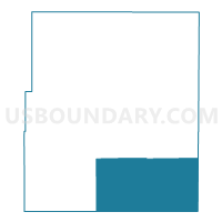
Outline

Summary
| Unique Area Identifier | 584145 |
| Name | Matfield Township Voting District |
| County | Chase County |
| State | Kansas |
| Area (square miles) | 122.39 |
| Land Area (square miles) | 121.78 |
| Water Area (square miles) | 0.62 |
| % of Land Area | 99.50 |
| % of Water Area | 0.50 |
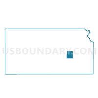
| Latitude of the Internal Point | 38.13058110 |
| Longtitude of the Internal Point | -96.48973630 |
Maps

Graphs
Select a template below for downloading or customizing gragh for Matfield Township Voting District, Chase County, Kansas


Neighbors
Neighoring Voting District (by Name) Neighboring Voting District on the Map
- Bazaar Township Voting District, Chase County, KS
- Homestead Township Voting District, Chase County, KS
- Madison Township Voting District, Greenwood County, KS
- Precinct 31, Lyon County, KS
- Salem Township Voting District, Greenwood County, KS
- Sycamore/Cassoday Voting District, Butler County, KS
Top 10 Neighboring County Subdivision (by Population) Neighboring County Subdivision on the Map
- Center township, Lyon County, KS (1,198)
- Madison township, Greenwood County, KS (983)
- Sycamore township, Butler County, KS (343)
- Matfield township, Chase County, KS (119)
- Bazaar township, Chase County, KS (93)
- Homestead township, Chase County, KS (45)
- Salem township, Greenwood County, KS (33)
Top 10 Neighboring Place (by Population) Neighboring Place on the Map
Top 10 Neighboring Unified School District (by Population) Neighboring Unified School District on the Map
- Southern Lyon County Unified School District 252, KS (2,893)
- Chase County Unified School District 284, KS (2,801)
- Flinthills Unified School District 492, KS (1,429)
- Madison-Virgil Unified School District 386, KS (1,356)
- Hamilton Unified School District 390, KS (549)
Top 10 Neighboring State Legislative District Lower Chamber (by Population) Neighboring State Legislative District Lower Chamber on the Map
- State House District 76, KS (20,876)
- State House District 70, KS (20,195)
- State House District 13, KS (17,996)
Top 10 Neighboring State Legislative District Upper Chamber (by Population) Neighboring State Legislative District Upper Chamber on the Map
Top 10 Neighboring 111th Congressional District (by Population) Neighboring 111th Congressional District on the Map
Top 10 Neighboring Census Tract (by Population) Neighboring Census Tract on the Map
- Census Tract 201, Butler County, KS (6,253)
- Census Tract 8, Lyon County, KS (3,525)
- Census Tract 9606, Chase County, KS (2,790)
- Census Tract 9656, Greenwood County, KS (2,162)
Top 10 Neighboring 5-Digit ZIP Code Tabulation Area (by Population) Neighboring 5-Digit ZIP Code Tabulation Area on the Map
- 67045, KS (3,644)
- 66860, KS (1,258)
- 66845, KS (1,232)
- 66865, KS (1,124)
- 66853, KS (429)
- 66842, KS (324)
- 66843, KS (205)
- 66862, KS (116)